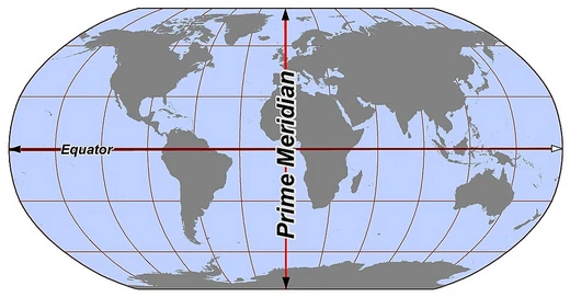
Meridian (geography)
A line of longitude connecting points of equal longitude.

A meridian in geography and geodesy is the locus connecting points of equal longitude, forming a line of longitude that runs from pole to pole. It is a fundamental reference for mapping, navigation, and timekeeping, with the prime meridian at Greenwich, England, serving as the global standard for zero degrees longitude.
- field
- Geography, geodesy, navigation
- key_concept
- Line of longitude connecting points of equal longitude
- prime_meridian
- Greenwich, England (IERS Reference Meridian)
- etymology
- From Latin 'meridies' meaning 'midday'
- related_terms
- a.m. (ante meridiem), p.m. (post meridiem)
Lore & Background
The term meridian comes from the Latin 'meridies', meaning 'midday', because the subsolar point passes through a given meridian at solar noon. By the early modern era, multiple locations were used as prime meridians, with Paris and Greenwich being the most acknowledged.
Reader's Guide
The meridian is a foundational concept in geography and geodesy, providing the coordinate system for longitude that enables precise mapping, navigation, and timekeeping. The meridian's role extends to defining the Western and Eastern Hemispheres, and its antimeridian near the International Date Line governs calendar date changes. Modern systems like WGS84 have refined the meridian's position, but its core function remains unchanged. The meridian also underpins the measurement of Earth rotation and the calculation of latitude via meridian passage of celestial objects. The distinction between true meridian and magnetic meridian is crucial for compass navigation, with magnetic declination being the angle between them. Standard meridians are used for time zones, with most countries adopting one of the 24 meridians closest to their position, though some use offsets of 30 or 45 minutes.
Did You Know?
- The term 'meridian' comes from Latin 'meridies' meaning 'midday', and gives rise to 'a.m.' and 'p.m.'.
The Core Principle of Hemispheric Division
In geography and cartography, the concept of hemispheres represents one of the most fundamental ways humans have organized their understanding of the planet. A hemisphere, at its simplest, is any division of Earth into two equal halves. While the most widely recognized splits are the northern and southern halves separated by the Equator, and the eastern and western halves separated by the Prime Meridian, the idea extends far beyond these two canonical lines. Scholars and mapmakers have long recognized that the globe can be partitioned along a variety of axes — geographic, cultural, religious, or even based on prominent physical features. These divisions are not merely academic exercises; they serve as practical frameworks for studying how populations, economies, and cultures are distributed across the planet. Whether examining demographic trends, socioeconomic patterns, or the spread of cultural practices, the hemispheric model provides a shared vocabulary that allows researchers to compare and contrast regions with clarity and precision.
The Geographical Framework of Latitude and Longitude
The standard geographical hemispheres rely on two primary sets of markers: latitudinal lines running north to south, and longitudinal lines running east to west. The Equator serves as the dividing line between the Northern and Southern Hemispheres, while the Prime Meridian — the zero-degree line of longitude — separates the Eastern and Western Hemispheres. Together, these two reference lines create a four-part grid that underpins virtually every world map and most global statistical analyses. The north-south division is particularly significant because latitude directly correlates with climate zones, seasonal variation, and the angle at which sunlight strikes the surface. The east-west division, anchored to the Prime Meridian, has historically carried cultural and political weight, as it was established by international agreement rather than by any natural feature. Both divisions are essential tools when researchers seek to understand how continents and oceans are distributed across the globe, and they form the backbone of discussions about the Global North and Global South, as well as the broader East-West dichotomy in both physical and human geography.
Cultural, Religious, and Feature-Based Alternative Divisions
Beyond the rigid lines of latitude and longitude, the hemispheric concept has been adapted to capture the human dimensions of the planet. Alternative hemisphere schemes can draw boundaries along cultural or religious lines, grouping populations not by where they sit relative to the Equator but by shared traditions, belief systems, or societal structures. This approach acknowledges that the natural world does not neatly align with the boundaries humans create around identity and community. In addition to cultural and religious divisions, scholars have also proposed hemispheres defined by prominent geographic features, using the physical landscape itself as the organizing principle. These alternative frameworks expand the utility of the hemispheric model, allowing researchers to explore how religion shapes regional development, how cultural boundaries influence trade and migration, and how the arrangement of major landforms and water bodies creates distinct environmental zones. By stepping outside the standard north-south and east-west grid, these alternative divisions reveal patterns that might otherwise remain invisible in conventional cartographic analysis.
The Land-Water Hemispheres
Among the most striking alternative hemisphere divisions is the land-water split, which seeks to maximize the prominence of either land or water in each half of the globe. The Land Hemisphere is centered near 47°N, 1°E, in the vicinity of Nantes, France. This division captures the largest possible concentration of the planet's solid surface, encompassing most of the world's continents and major landmasses within a single hemisphere. Its counterpart, the Water Hemisphere, is centered near 47°S, 179°W, in the South Pacific Ocean just southwest of New Zealand's Chatham Islands. This half of the Earth contains the greatest possible expanse of open water, drawing in the bulk of the Indian, Pacific, and Southern Oceans. Together, these two complementary hemispheres offer a powerful visual and analytical tool: they make tangible the fact that Earth is a planet of both vast continents and even vaster oceans, and they provide a concrete reference point for discussions about the global distribution of land and sea.
Frequently Asked Questions
What is a meridian in geography?
A meridian is a line of longitude that links every point sharing the same longitude value, stretching continuously from the North Pole to the South Pole. It forms one of the essential reference lines used to chart positions on Earth's surface.
What is the prime meridian and where is it located?
The prime meridian is the zero-degree longitude line established at Greenwich, England, and it serves as the global reference point from which all other longitudes are measured east or west. It is formally designated as the IERS Reference Meridian.
Where does the word 'meridian' come from?
The term traces back to the Latin word 'meridies,' meaning 'midday,' because the sun crosses a location's local meridian at its highest daily point. This same root gives us the time-of-day abbreviations a.m. (ante meridiem) and p.m. (post meridiem).
Why are meridians important for navigation and timekeeping?
Meridians give navigators a fixed longitudinal grid to determine east-west position at sea or in the air. They also anchor the world's time-zone system, since each 15-degree meridian interval corresponds to one hour of solar time.
More in Lines & Hemispheres 1-24
Elsewhere in the Lines & Hemispheres universe
Spotted an error? Know more?
This is a living reference — every entry is fact-audited, and reader corrections feed straight into our audit queue. Suggest an edit · See this site's audit record