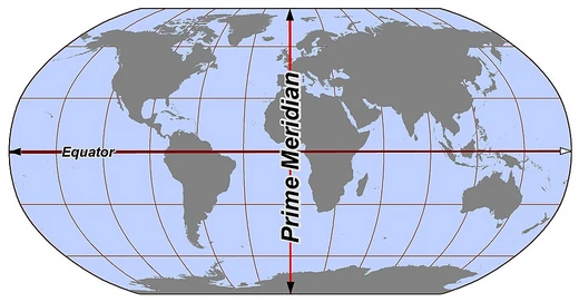
Circle of latitude
Parallel circles defining latitude on Earth.

A circle of latitude, or line of latitude, is an abstract east–west small circle on Earth connecting all locations at a given latitude coordinate, ignoring elevation. Often called parallels because they are parallel to each other, these circles are fundamental to geographic coordinate systems and mapmaking. Their length decreases with distance from the Equator, which is the longest and the only great circle among them.
- type
- Geographic concept
- key_feature
- Parallel east–west circles at constant latitude
- longest_circle
- Equator (0° latitude)
- number_of_integral_circles
- 89 per hemisphere between Equator and poles
- major_circles
- Arctic Circle, Tropic of Cancer, Equator, Tropic of Capricorn, Antarctic Circle
- used_for
- Borders, navigation, map projections
Lore & Background
Circles of latitude are often called parallels because planes containing any of these circles never intersect each other. A location's position along a circle of latitude is given by its longitude. Unlike circles of longitude, which are all great circles, circles of latitude get smaller as distance from the Equator increases; their length can be calculated by a sine or cosine function. For example, the 60th parallel north or south is half as long as the Equator, stemming from cos(60°) = 0.5. There are five major circles of latitude: the Arctic Circle (66°33′51.0″ N), Tropic of Cancer (23°26′09.0″ N), Equator (0°), Tropic of Capricorn (23°26′09.0″ S), and Antarctic Circle (66°33′51.0″ S). These circles, excluding the Equator, mark divisions between the five principal geographical zones. On maps, circles of latitude may appear differently depending on the projection. On an equirectangular projection they are horizontal, parallel, and equally spaced. On a Mercator projection they are more widely spaced near the poles, while on a Gall–Peters projection they are spaced more closely near the poles. Arcs of circles of latitude are sometimes used as boundaries between countries or regions, such as the northern border of Colorado at 41° N and the southern border at 37° N, or roughly half the length of the border between the United States and Canada following 49° N.
Reader's Guide
Circles of latitude are essential for geographic orientation, navigation, and defining climatic zones. The Equator divides Earth into Northern and Southern Hemispheres and is the only circle of latitude that is a great circle. The major circles—Arctic Circle, Tropic of Cancer, Equator, Tropic of Capricorn, and Antarctic Circle—mark the boundaries of the polar, temperate, and tropical zones, influencing climate and daylight patterns. These circles also serve practical purposes in establishing political borders where natural features are lacking, as seen in many North American state and national boundaries. On other planets, similar circles can be defined based on axial tilt relative to their orbital planes.
Did You Know?
- The 60th parallel north or south is half as long as the Equator, because cos(60°) = 0.5.
- There are 89 integral (whole degree) circles of latitude between the Equator and the poles in each hemisphere.
- On the Mercator projection, circles of latitude are more widely spaced near the poles to preserve local scales and shapes.
Geometric Structure and Measurement
A circle of latitude is an abstract east–west ring that links every point on Earth sharing the same latitude coordinate, setting aside elevation differences. Because the planes containing these rings never intersect one another, they are commonly called parallels. Unlike the great circles formed by lines of longitude, which all pass through Earth's center, parallels shrink progressively as they move away from the Equator toward the poles. The latitude value itself represents the angle measured at Earth's center between the Equatorial plane and the circle in question, with the Equator sitting at 0° and the poles at 90° north and south.
The Five Principal Circles and Axial Tilt
Five circles of latitude hold special significance in geography and astronomy: the Arctic Circle, Tropic of Cancer, Equator, Tropic of Capricorn, and Antarctic Circle, listed from north to south. The Equator's position is fixed at 90 degrees from Earth's rotational axis, but the remaining four depend on the tilt of that axis relative to Earth's orbital plane around the Sun. The polar circles mark the latitudes where, at the June and December solstices, the Sun can remain continuously above or below the horizon for a full 24 hours. Their latitude equals 90° minus the axial tilt. The tropical circles, by contrast, indicate the northernmost and southernmost points where the Sun appears directly overhead at solstice, and their latitude equals the axial tilt itself. Had Earth's axis stood perfectly upright, none of these four circles would exist: the Sun would merely skim the horizon at the poles and pass overhead at the equator every day.
Representation on Maps and Projections
How parallels appear on a flat map depends entirely on the projection chosen. On an equirectangular projection centered on the Equator, circles of latitude render as horizontal, parallel, and equally spaced lines. Cylindrical and pseudocylindrical projections also keep them horizontal and parallel, but adjust their vertical spacing to serve different cartographic purposes. The Mercator projection stretches the spacing near the poles so that local shapes and scales remain true, while the Gall–Peters projection compresses spacing near the poles to preserve accurate area comparisons. In both of these systems, every parallel meets all meridians at a right angle. On a true ellipsoidal or spherical surface, all parallels except the Equator qualify as rhumb lines. Most non-cylindrical and non-pseudocylindrical projections, however, depict parallels as neither straight nor parallel, and their spacing varies irregularly across the map. This means that the same geographic latitude can look dramatically different depending on which projection a cartographer selects, making the choice of projection a fundamentally interpretive act.
Parallels as Political Boundaries
Beyond their mathematical and astronomical roles, circles of latitude have served as practical tools for drawing political boundaries. Where distinctive natural features such as rivers or mountain ranges are absent—as in vast deserts—arc segments of parallels provide a convenient, objective line on a map to separate territories. This practice is especially prominent in North America, where nations and states were largely delineated by straight lines that correspond to portions of circles of latitude. Colorado, for example, is bounded to the north by the 41st parallel and to the south by the 37th parallel. Roughly half of the international border between the United States and Canada traces the 49th parallel north. These artificial boundaries, drawn as simple lines on a map, contrast sharply with the organic, winding borders found in regions shaped by rivers or coastlines. The use of parallels in this way reflects a preference for geometric simplicity and administrative clarity, turning an abstract geometric concept into a tangible dividing line that has shaped the political landscape of entire continents.
Frequently Asked Questions
What is a circle of latitude?
A circle of latitude is an imaginary east–west ring encircling the Earth at a fixed angular distance from the Equator. Every point on that ring shares the same latitude value, and the circles are commonly called 'parallels' because they run parallel to one another.
How does a circle of latitude differ from a meridian (line of longitude)?
Meridians are great circles stretching pole-to-pole, whereas circles of latitude are small circles wrapping the globe east to west. Only the Equator qualifies as a great circle among the parallels; every other parallel is shorter in circumference.
Why is the Equator the longest circle of latitude?
At 0° latitude the Earth's girth is at its maximum, so the Equator is the sole parallel that also counts as a great circle. Each successive parallel toward either pole shrinks in length until it collapses to a point at the pole itself.
What are the five major circles of latitude?
The five traditionally named parallels are the Arctic Circle, Tropic of Cancer, Equator, Tropic of Capricorn, and Antarctic Circle. They mark key thresholds for seasonal solar angles, polar day and night, and the tropical belt.
How many circles of latitude exist?
Counting only whole-degree parallels, there are 89 circles in each hemisphere between the Equator and the pole, with the Equator itself as the shared zero line. Because latitude is a continuous coordinate, an infinite number of circles can be defined at fractional values.
More in Lines & Hemispheres 1-24
Elsewhere in the Lines & Hemispheres universe
Spotted an error? Know more?
This is a living reference — every entry is fact-audited, and reader corrections feed straight into our audit queue. Suggest an edit · See this site's audit record