180th meridian
The 180th meridian divides hemispheres and anchors the International Date Line.

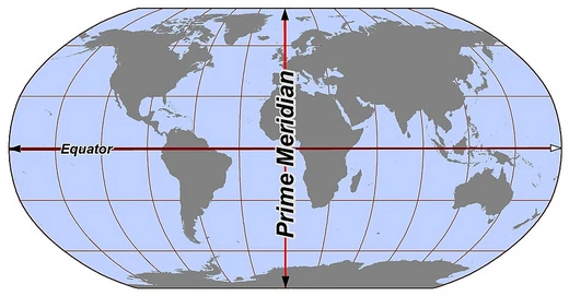
It forms a great ellipse with the prime meridian that divides the Earth into the Western and Eastern Hemispheres, and serves as the basis for the International Date Line.
- type
- Geographical line of longitude
- also_known_as
- Antimeridian
- location
- Pacific Ocean, Russia, Fiji, Antarctica
- function
- Basis for the International Date Line
- crossed_by_roads
- Fiji and Russia
- software_issues
- Causes representation problems in GeoJSON, OpenStreetMap, QGIS, Google Maps
Lore & Background
The 180th meridian passes mostly through open Pacific waters but also crosses land in Russia, Fiji, and Antarctica. Its role as the basis for the International Date Line causes the line to snake around national borders to maintain date consistency within territories of Russia, the United States, Kiribati, Fiji, and New Zealand. The only places where roads cross this meridian are in Fiji and Russia; Fiji has several such roads and some buildings very close to it, while Russia has three roads in the Chukotka Autonomous Okrug.
Reader's Guide
The 180th meridian is significant as the foundation of the International Date Line, which adjusts date boundaries to avoid splitting countries. It also creates practical challenges in geographic software: many libraries split the world at this meridian, making it difficult to represent areas or lines crossing it. For example, GeoJSON specifications recommend splitting geometries to avoid crossing the antimeridian, OpenStreetMap splits areas like Russia's boundary at this line, and navigation in Google Maps is not possible across the meridian on Taveuni island, Fiji. These issues highlight the meridian's role as both a conceptual boundary and a technical hurdle in digital mapping.
Did You Know?
- The 180th meridian is also called the antimeridian.
- It passes through land in Russia, Fiji, and Antarctica.
- Only Fiji and Russia have roads that cross this meridian.
- In Google Maps, navigation is not possible across the 180th meridian on Taveuni island, Fiji.
Geographic Definition and Hemispheric Division
The 180th meridian, commonly called the antimeridian, occupies a unique position in the global coordinate system. This dual designation reflects the fact that the line is its own mirror—there is no further east or west to travel. Together with the prime meridian running through Greenwich, England, the antimeridian completes a full great ellipse around the planet. This closed loop serves as the fundamental dividing line between the Western and Eastern Hemispheres, giving cartographers and navigators a consistent framework for organizing the Earth's surface into two halves. The simplicity of this division belies the complexity it introduces wherever the line intersects with political boundaries, time zones, and digital mapping systems.
Physical Path and the International Date Line
Tracing the antimeridian from the North Pole to the South Pole reveals a path dominated by open Pacific waters, though it does clip land in three places: Russia, Fiji, and Antarctica. Along the way, it threads through the Aleutian Island chain in US territory and passes between several island groups, including the Gilbert and Phoenix Islands of Kiribati, the North and Kermadec Islands of New Zealand, and the Bounty and Chatham Islands, also belonging to New Zealand. Perhaps the meridian's most consequential role is serving as the backbone for the International Date Line. Because a straight line would awkwardly bisect inhabited territories, the Date Line deliberately snakes around the borders of Russia, the United States, Kiribati, Fiji, and New Zealand.
Road Crossings and Human Presence
Despite its vast stretch across ocean, the antimeridian intersects human-built infrastructure in remarkably few places. The only locations on Earth where roads actually cross this meridian are in Fiji and Russia. In Fiji, several roads intersect the line, and a handful of buildings sit very close to it, making the antimeridian a tangible, walkable feature rather than an abstract coordinate. In Russia, three roads in the Chukotka Autonomous Okrug cross the meridian, placing this far northeastern corner of the country in a unique position where daily life straddles the boundary between the Eastern and Western Hemispheres. Beyond these road crossings, the meridian's interaction with human settlement is largely indirect—most of its path runs through open water or remote island chains. The fact that only a handful of paved routes and a few structures come within touching distance of the line underscores just how much of the antimeridian remains a feature of the natural world rather than the built one.
Digital Mapping and Software Challenges
The antimeridian poses persistent headaches for geographic software and digital mapping tools. Many libraries and data formats project the spherical Earth onto a flat rectangle, and that rectangle is very often sliced precisely at the 180th meridian. This design choice makes straightforward operations—such as drawing a polygon or a line that crosses the line—surprisingly difficult. The GeoJSON specification, for instance, strongly recommends splitting any geometry that would cross the antimeridian into separate parts. In OpenStreetMap, large areas like Russia's national boundary are split at the meridian, and no directions engine can compute a route that crosses from one side to the other. QGIS may render lines and polygons in a visually wrapped manner when they cross the line. Even Google Maps fails to provide navigation across the antimeridian on Taveuni Island in Fiji, restricting users to routes that stay on a single side.
Frequently Asked Questions
What are 180th meridian's powers or role?
It acts as the anchor for the International Date Line, dictating where a fresh calendar day begins. Paired with the prime meridian, it also forms a great ellipse that carves the planet into the Eastern and Western Hemispheres.
How does 180th meridian's story end?
Because it is a fixed coordinate on Earth's surface rather than a character with a plot arc, it never truly 'ends'—it simply persists as a permanent divider. Its ongoing role is to keep anchoring the date line and separating the two hemispheres indefinitely.
Why is 180th meridian important?
It is the single reference line that lets the world agree on where one day ends and the next begins via the International Date Line. It also provides the boundary that splits the globe into its Eastern and Western Hemispheres.
What are 180th meridian's known weaknesses or complications?
It is notorious for producing representation glitches in mapping tools such as GeoJSON, OpenStreetMap, QGIS, and Google Maps. It is also one of the rare longitudes actually intersected by roads, specifically in Fiji and Russia.
More in Lines & Hemispheres 1-24
Elsewhere in the Lines & Hemispheres universe
Spotted an error? Know more?
This is a living reference — every entry is fact-audited, and reader corrections feed straight into our audit queue. Suggest an edit · See this site's audit record