Antarctic Circle
Southernmost major latitude circle marking the Antarctic region.

The Antarctic Circle is the most southerly of the five major circles of latitude that mark maps of Earth. Its position is not fixed and currently runs 66°33′51.0″ south of the Equator, though this figure may be slightly inaccurate because it does not allow for the effects of astronomical nutation.
- type
- Circle of latitude
- current_latitude
- 66°33′51.0″ south of the Equator
- drift_speed
- about 14.5 m (48 ft) per year southwards
- area_south_of_circle
- about 20,000,000 km² (7,700,000 sq mi)
- percentage_of_earth_surface
- roughly 4%
- axial_tilt_fluctuation_period
- over a 41,000-year period
Lore & Background
The Antarctic Circle is the northernmost latitude in the Southern Hemisphere at which the centre of the sun can remain continuously above the horizon for twenty-four hours. South of this circle, the Sun is above the horizon for 24 continuous hours at least once per year and is below the horizon for 24 continuous hours at least once per year. Directly on the Antarctic Circle these events occur exactly once per year: at the December and June solstices, respectively. However, because of atmospheric refraction and mirages, and because the sun appears as a disk and not a point, part of the midnight sun may be seen up to about 50 minutes north of the Antarctic Circle on the night of the southern summer solstice; similarly, part of the sun may be seen up to about 50 minutes south of the Antarctic Circle on the day of the southern winter solstice.
Reader's Guide
Its latitude depends on Earth's axial tilt, which fluctuates within a margin of more than 2° over a 41,000-year period due to tidal forces from the Moon's orbit. The circle is currently drifting southwards at about 14.5 meters per year. Most of the continent of Antarctica lies within the Antarctic Circle. There is no permanent human population south of the circle, but several research stations are inhabited by rotating teams of scientists. In previous centuries, semi-permanent whaling stations were established, and some whalers lived there for a year or more. At least eleven children have been born in Antarctica, though in stations north of the Antarctic Circle.
Did You Know?
- The Antarctic Circle is the northernmost latitude in the Southern Hemisphere at which the Sun can remain continuously above or below the horizon for 24 hours.
- The latitude of the Antarctic Circle is equal to 90° minus the Earth's axial tilt.
- The main long-term cycle causes the axial tilt to fluctuate between about 22.1° and 24.5° with a period of 41,000 years.
- As of January 1, 2023, the mean axial tilt was 23°26′10.633″, decreasing by about 0.468″ per year.
- On the Mercator projection, circles of latitude are more widely spaced near the poles to preserve local scales and shapes.
Geometry of a Shrinking Parallel
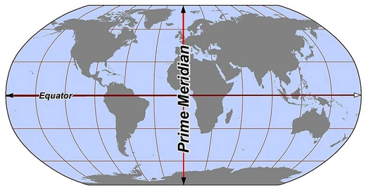
The Antarctic Circle is a small circle of latitude — an abstract east–west ring connecting every point on Earth's surface at the same angular distance from the Equator. Unlike the Equator itself, which is the only parallel that qualifies as a great circle centered on Earth's core, the Antarctic Circle is centered solely on the planet's rotational axis and therefore smaller in circumference. All parallels are parallel to one another in the sense that the planes containing them never intersect, yet their lengths shrink as one moves away from the Equator. The length of any given parallel can be derived with a simple cosine function: at 60° latitude the ring is half the Equator's length, and at the Antarctic Circle's roughly 66.5° south, it is even shorter. The Equator sits at 0°, the poles at 90°, and the Antarctic Circle occupies the position approximately 66°33′ south, making it one of the five principal latitude markers that divide Earth into its major geographical zones.
Where the Sun Refuses to Set
The Antarctic Circle earns its distinction through a singular astronomical behavior: it marks the northernmost latitude in the Southern Hemisphere where the Sun can hover continuously above the horizon for an entire 24-hour period during the December solstice, or dip entirely below it during the June solstice. This polar day and polar night phenomenon is a direct consequence of Earth's axial tilt. By definition, the circle's latitude equals 90° minus the obliquity of the ecliptic — the angle between Earth's rotational axis and the plane of its orbit around the Sun. If that tilt were zero and the axis stood perfectly upright, no such circles would exist; at the poles the Sun would merely trace the horizon, and at the equator it would always rise due east, pass overhead, and set due west. The Antarctic Circle, then, is the boundary of a world where daylight and darkness can each last an entire day.
A Line That Slowly Drifts
Far from being an immutable line etched into the planet, the Antarctic Circle creeps in and out over geological time. Its exact position is governed by the obliquity of the ecliptic, which itself oscillates due to the superimposition of numerous gravitational cycles of varying periods. The dominant long-term cycle swings the axial tilt between approximately 22.1° and 24.5° over a span of roughly 41,000 years. As of the early 2000s the mean tilt was measured at 23°26′21.406″, and by January 2023 it had shifted to 23°26′10.633″, reflecting a present-day average decrease of about 0.468 arcseconds per year. Because the circle's latitude is 90° minus this tilt, even a tiny annual change nudges the boundary. The value cited for 28 August 2026 — 66°33′51.0″ south — is therefore a snapshot, not a permanent coordinate, and will differ measurably from the value recorded a century ago or a millennium hence.
Drawing the Circle on a Flat Map
Translating the Antarctic Circle from a three-dimensional sphere onto a two-dimensional map introduces a host of representational choices. On an equirectangular projection centered on the Equator, the circle appears as a perfectly horizontal, evenly spaced line. On cylindrical and pseudocylindrical projections it remains horizontal and parallel to other parallels, but the vertical spacing between lines shifts to serve different cartographic goals. The Mercator projection, for instance, stretches the spacing near the poles so that local shapes and angles are preserved, while the Gall–Peters projection compresses that spacing to keep relative areas accurate. On most non-cylindrical projections the circle is neither straight nor parallel to its neighbors. Despite these visual distortions, the Antarctic Circle retains its practical utility: arcs of latitude like it have long served as artificial boundaries between nations or regions where no natural landmark offers a convenient dividing line, a role seen in the straight-line borders of many North American states and the roughly 49° N segment of the U.S.–Canada boundary.
Frequently Asked Questions
What is the Antarctic Circle?
The Antarctic Circle is the southernmost of Earth's five principal latitude circles and serves as the defining boundary of the Antarctic region. The strip of territory lying just to its north is classified as the Southern Temperate Zone.
Where exactly is the Antarctic Circle located?
It currently sits at roughly 66°33′51.0″ south of the Equator, although that figure can wobble slightly because it does not fully account for the effects of astronomical nutation.
How big is the Antarctic Circle?
The circle's circumference measures approximately 16,000 kilometres (around 9,900 miles), and the entire area enclosed south of it covers roughly 20 million square kilometres, accounting for about four percent of Earth's total surface.
Does the Antarctic Circle's position change over time?
Yes. The line is not permanently fixed; it creeps southward at a pace of roughly 14.5 metres (48 feet) per year, so its exact latitude shifts gradually.
Why is the Antarctic Circle important in the Lines & Hemispheres series?
As the most southerly major latitude line, it draws the definitive border between the Antarctic and the rest of the planet, giving the region its distinct identity and anchoring the encyclopedia's exploration of Earth's far-southern geography.
More in Lines & Hemispheres 1-24
Related in Lines & Hemispheres
Links follow this subject's own source article.
Elsewhere in the Lines & Hemispheres universe
Spotted an error? Know more?
This is a living reference — every entry is fact-audited, and reader corrections feed straight into our audit queue. Suggest an edit · See this site's audit record