Equator
Imaginary line dividing Earth into Northern and Southern Hemispheres.

The equator is the circle of latitude that divides Earth into the Northern and Southern Hemispheres. The term can also be used for any other celestial body that is roughly spherical.
Lore & Background
The equator is one of the five notable circles of latitude on Earth, the others being the Arctic Circle, Antarctic Circle, Tropic of Cancer, and Tropic of Capricorn. It is the only line of latitude that is also a great circle, meaning its plane passes through the center of the globe. The plane of Earth's equator, when projected outward to the celestial sphere, defines the celestial equator. The name derives from medieval Latin 'aequator', in the phrase 'circulus aequator diei et noctis', meaning 'circle equalizing day and night'.
Reader's Guide
The equator is significant as the fundamental reference line for latitude, defining 0° latitude and serving as the baseline for geographic coordinate systems. Its location is not truly fixed; the true equatorial plane is perpendicular to Earth's rotation axis, which drifts about 9 metres during a year. Geological samples show the equator significantly changed positions between 48 and 12 million years ago. The equator experiences stable daytime temperatures year-round, with sunlight appearing almost directly overhead daily. On the equinoxes, the subsolar point crosses the equator, and all latitudes have nearly equal day and night.
Did You Know?
- The equator passes through the land of thirteen sovereign states.
- Indonesia is the country straddling the greatest length of the equatorial line across both land and sea.
- Despite its name, no part of Equatorial Guinea lies on the equator.
The Equator as the Primary North-South Divider
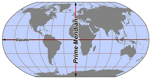
The Equator serves as the principal latitudinal line that splits Earth into two equal halves—the northern and southern hemispheres. This division is the most fundamental way cartographers and geographers partition the globe, working in tandem with the Prime Meridian to create the familiar four-way split into northern, southern, eastern, and western quarters. The use of these hemispheric divisions is not merely a cartographic convenience; it underpins how scholars study the geographic distribution of populations, cultural differences, and socioeconomic patterns across the planet. Whether analyzing demographic trends or mapping cultural boundaries, the Equator provides the baseline reference from which latitudinal positions are measured, making it indispensable in both practical navigation and academic research into how human societies are distributed across the globe's surface.
The Equator Within the Broader Hemispheric Framework
While the Equator is perhaps the most recognizable dividing line on Earth, it operates as part of a larger system of hemispheric divisions. The standard geographical framework pairs the Equator's north-south split with the Prime Meridian's east-west split, creating four quadrants that serve as the default reference for studying the planet. However, the concept of hemispheres extends well beyond these two primary lines. Divisions can be drawn along cultural or religious boundaries, or crafted to emphasize particular geographic features. This means the Equator, while central to the most common model, is one of several possible axes around which the globe can be conceptually halved. The flexibility of the hemispheric idea allows researchers to choose the division that best illuminates the particular phenomenon they are investigating, whether that be the spread of a faith, the clustering of landmasses, or the distribution of oceanic waters.
Cultural and Religious Hemisphere Divisions
The Equator's role as a purely geographic marker stands in contrast to alternative hemisphere schemes that draw their boundaries along cultural or religious lines rather than latitudinal coordinates. In these frameworks, the dividing line between two hemispheres may follow the spread of a particular faith or the boundaries of a cultural sphere, producing divisions that bear no direct relationship to the Equator's position at zero degrees latitude. Such culturally defined hemispheres are applied when scholars wish to examine how belief systems, traditions, or societal structures cluster across the globe in ways that a simple north-south or east-west split would obscure. This approach acknowledges that the Equator, while geographically precise, does not always align with the human patterns that researchers seek to understand, and that meaningful divisions of the planet can be drawn according to the logic of culture rather than the logic of coordinates.
The Equator Versus Feature-Based Divisions
An intriguing contrast to the Equator's symmetrical north-south division is the concept of feature-based hemispheres, which are designed to maximize the prominence of a particular geographic element in each half. The most striking example is the land-water division: the Land Hemisphere, centered near Nantes, France, captures the greatest possible concentration of continental landmasses, while the Water Hemisphere, centered in the South Pacific southwest of New Zealand's Chatham Islands, encompasses the largest possible expanse of ocean, drawing in most of the Indian, Pacific, and Southern Oceans. These divisions bear no allegiance to the Equator's position; their centers are determined entirely by the geometry of land and water distribution. This reveals that the Equator, for all its centrality in standard cartography, is just one of many valid ways to conceptually bisect the planet, and that the most natural division depends entirely on what feature a researcher wishes to foreground.
Frequently Asked Questions
What is the Equator in the Lines & Hemispheres series?
The Equator is the zero-degree latitude circle that splits Earth into its Northern and Southern Hemispheres. It is purely imaginary—no physical marker exists on the ground—and sits exactly halfway between the two poles.
Where exactly does the Equator sit on a map?
It runs along 0° latitude, equidistant from the North Pole and the South Pole, threading through parts of South America, Central Africa, and Southeast Asia.
Does the term 'equator' apply only to Earth?
No—any roughly spherical celestial body can have its own equatorial line defined at zero degrees latitude, so the word is used for planets and moons well beyond Earth.
More in Lines & Hemispheres 1-24
Elsewhere in the Lines & Hemispheres universe
Spotted an error? Know more?
This is a living reference — every entry is fact-audited, and reader corrections feed straight into our audit queue. Suggest an edit · See this site's audit record