Longitude
Geographic coordinate specifying east-west position on Earth.

Longitude is a geographic coordinate that specifies the east-west position of a point on the surface of the Earth or another celestial body. It is an angular measurement, usually expressed in degrees and denoted by the Greek letter lambda (λ). The concept was first developed by ancient Greek astronomers, and determining longitude accurately at sea took centuries of effort by some of the greatest scientific minds.
- field
- Geography, Navigation, Astronomy
- known_for
- East-west coordinate system; prime meridian; relation to time measurement
- key_invention
- Chronometer by John Harrison; lunar distance method by Tobias Mayer and Nevil Maskelyne
- prime_meridian
- International Reference Meridian near Royal Observatory, Greenwich, London
- measurement_unit
- Degrees, denoted by λ
Lore & Background
The concept of longitude was first developed by ancient Greek astronomers. He proposed determining longitude by comparing local time of a lunar eclipse at two places. Claudius Ptolemy in the 2nd century AD developed a mapping system using curved parallels and a prime meridian through the Canary Islands, though his data often led to errors such as overestimating the Mediterranean's length by about 70%.
Reader's Guide
Longitude's significance lies in its fundamental role in navigation, cartography, and timekeeping. The relationship between longitude and time—a 15° difference corresponding to one hour—enabled methods such as lunar eclipses, lunar distances, and chronometers to determine position at sea. The development of accurate chronometers by John Harrison and the lunar distance method solved the longitude problem that had plagued maritime navigation for centuries. Telegraph and later wireless time signals allowed precise determination on land and at sea. Radio navigation systems after World War II became standard for commercial shipping until replaced by GPS in the early 1990s. The prime meridian at Greenwich became the international reference, standardizing global time zones and coordinates. Longitude determination drove advances in astronomy, clock-making, and communications, and remains essential for modern GPS and mapping.
Did You Know?
- Hipparchus in the 2nd century BC proposed determining longitude by comparing local time of a lunar eclipse at two places.
- Al-Battānī determined the longitude difference between Antakya and Raqqa with an error of less than 1° using lunar eclipses.
The Geometry of East-West Position
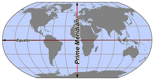
Longitude is the angular coordinate that pinpoints where a location sits along the east-west axis of a sphere, whether that sphere is Earth or another celestial body. It is conventionally written in degrees and marked with the Greek letter lambda. Imaginary semicircular arcs called meridians stretch from pole to pole, linking every point that shares the same longitude value. The zero-degree reference, the prime meridian, is fixed by international convention near the Royal Observatory in Greenwich, south-east London. Values east of that line are positive; values west are negative. A location's north-south placement along any given meridian is described separately by latitude, roughly the angle between the equatorial plane and the local vertical. In practice, longitude is usually referenced to the geodetic normal or the direction of gravity, though small gravitational irregularities can cause the astronomical longitude to deviate slightly from the ordinary geodetic value. Together, these two coordinates form the backbone of every map, navigation chart, and satellite positioning system we rely on today.
Longitude, Time, and the Sun
Because the Earth rotates, a point's longitude is intimately tied to its local solar time. A shift of fifteen degrees in longitude translates into a one-hour difference in when the Sun crosses the local meridian, a direct consequence of each location's changing angle relative to the Sun throughout a day. This relationship means that if you can compare your local solar time against a known absolute reference, you can back-calculate your east-west position. In earlier centuries, that absolute reference might come from a celestial event visible from two separated places simultaneously, such as a lunar eclipse. In later eras, the reference could be a time signal carried by telegraph or radio. The underlying principle is deceptively simple, yet turning it into a dependable, repeatable method of finding one's longitude at sea proved extraordinarily difficult, demanding centuries of ingenuity and the work of some of history's most brilliant scientific minds.
From Alexandria to the Age of Exploration
The intellectual roots of longitude stretch back to ancient Greece. He also sketched a method for finding longitude by comparing the local time of a lunar eclipse at two sites, revealing an early grasp of the longitude-time link. Claudius Ptolemy, two centuries later, refined mapping with curved parallels and gathered positional data from Britain to the Middle East, choosing a prime meridian through the Canary Islands so all values stayed positive. After Rome's collapse, European interest waned, but Hindu and Muslim astronomers kept the tradition alive. Al-Battānī, for instance, used simultaneous naked-eye observations of two lunar eclipses to measure the longitude gap between Antakya and Raqqa to within one degree. In the later Middle Ages, European scholars revived the discipline through contact with Arab learning in Spain and North Africa. Columbus himself attempted lunar-eclipse longitude fixes during his second and fourth voyages, though his results carried errors of 13 and 38 degrees respectively.
The Clock That Solved the Sea
For centuries, determining longitude on open water remained the great unsolved problem of navigation. At sea, however, ocean swell made precise observations far harder, and pendulum clocks simply could not keep reliable time in a rolling ship. Two approaches ultimately earned recognition: the lunar-distance method, made practical by Tobias Mayer's tables and Nevil Maskelyne's nautical almanac, and the marine chronometers crafted by Yorkshire carpenter and clockmaker John Harrison.
Frequently Asked Questions
What is Longitude in the Lines & Hemispheres canon?
Longitude is the angular coordinate that marks a point's east-west position on Earth or any other celestial body. It is expressed in degrees and conventionally written with the Greek letter lambda (λ).
What role does Longitude play in navigation and astronomy?
Paired with latitude, longitude gives a full two-dimensional fix on a globe, which was vital for sailors plotting courses at sea. Its direct link to local solar time made it central to celestial navigation and the development of timekeeping.
How was the longitude problem finally solved?
John Harrison's marine chronometer and the lunar-distance technique refined by Tobias Mayer and Nevil Maskelyne gave navigators practical, reliable methods for determining their east-west position. Those breakthroughs ended centuries of dangerous uncertainty on the high seas.
Why is Longitude considered so important?
Without an accurate east-west coordinate, mariners could not avoid reefs or plot safe passages, resulting in countless wrecks. It also underpins modern time zones, GPS positioning, and essentially every mapping system in use today.
Where is the prime meridian and why does it matter?
The International Reference Meridian, which defines zero degrees longitude, passes through the Royal Observatory in Greenwich, London. All east and west longitude values are measured outward from that single reference line.
More in Lines & Hemispheres 25-28
Elsewhere in the Lines & Hemispheres universe
Spotted an error? Know more?
This is a living reference — every entry is fact-audited, and reader corrections feed straight into our audit queue. Suggest an edit · See this site's audit record