Geodetic datum
A reference frame for unambiguously representing Earth positions.

A geodetic datum (or geodetic system) is a global reference frame for unambiguously representing positions on Earth using geodetic coordinates or geocentric coordinates. Datums are crucial to technologies based on spatial location, including geodesy, navigation, surveying, geographic information systems, remote sensing, and cartography. A horizontal datum measures horizontal position in latitude and longitude; a vertical datum measures elevation or depth relative to a standard origin such as mean sea level; a three-dimensional datum unifies both.
- field
- Geodesy, Surveying, Cartography
- known_for
- Providing a reference frame for spatial location on Earth and other celestial bodies
- types
- Horizontal, vertical, three-dimensional, planetary
- components
- Reference ellipsoid or geoid, origin, control points
Lore & Background
The spherical nature of Earth was known by ancient Greeks, who developed latitude and longitude and early astronomical methods for measuring them. These methods were preserved and advanced by Muslim and Indian astronomers, sufficient for global exploration in the 15th and 16th centuries.
Reader's Guide
Geodetic datums are foundational to any technology or technique based on spatial location. Before GPS, there was no precise way to measure positions far from reference points used in local datums, such as the Prime Meridian at Greenwich Observatory, the Equator, or the nearest coast for sea level. Astronomical and chronological methods had limited precision over long distances. The rise of GPS and its WGS 84 datum supplanted most earlier datums in many applications, as WGS 84 is intended for global use. However, because Earth is an imperfect ellipsoid, local datums can give more accurate representation of specific areas—for example, OSGB36 approximates the geoid over the British Isles better than WGS 84. Despite this, the benefits of a global system have led to widespread adoption of WGS 84. A standard datum specification includes a model for Earth's shape (reference ellipsoid or geoid), an origin tied to a known location, and multiple control points precisely measured from that origin. Coordinates referred to different datums have undefined relationships and can only be approximated; datum shift can reach kilometers if a point is far from the origin of one or both datums.
Did You Know?
- A horizontal datum binds a reference ellipsoid to the physical Earth using monumented geodetic control points.
- The WGS 84 datum is intended for global use, unlike most earlier datums that were local or regional.
- Mars has no oceans and thus no sea level, but at least two martian datums have been used to locate places there.
- Coordinates in NAD 83 can differ from NAD 27 by up to several hundred feet.
Ancient Origins and the Long Road to a Global Grid
The invention of a geographic coordinate system is generally credited to Eratosthenes of Cyrene, who composed his now-lost Geography at the Library of Alexandria in the 3rd century BC. Hipparchus of Nicaea improved the system a century later, deriving latitude from stellar measurements and longitude from lunar eclipse timings rather than dead reckoning. Marinus of Tyre then compiled an extensive gazetteer and a mathematically plotted world map, measuring east from a prime meridian at the Fortunate Isles off western Africa and north-south from Rhodes. Ptolemy's 2nd-century Geography kept that meridian but measured latitude from the Equator. After 9th-century Arabic translations, Al-Khwārizmī corrected Mediterranean length errors, shifting medieval Arabic cartography to a meridian roughly ten degrees east of Ptolemy's. The Dominican Republic voted against; France and Brazil abstained.
Three Ways to Define Latitude
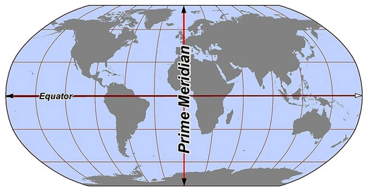
Latitude can be defined in three distinct ways depending on the coordinate system in use. In each case, the latitude is the angle between the equatorial plane and a line connecting the surface point to a second point on that plane. What changes is how that second point is located. In an astronomical coordinate system, the second point is where the plumb-bob vertical, extended from the surface point, meets the equatorial plane. In a geodetic coordinate system, it is where the normal vector to the ellipsoid surface at that point intersects the equatorial plane. In a geocentric system, the second point is simply the center of the Earth. The path joining all points sharing the same latitude traces a circle when viewed from above either pole; these circles are called parallels because they run parallel to the equator and to one another. The North Pole sits at 90° N, the South Pole at 90° S, and the 0° parallel—the equator—serves as the fundamental plane of the entire system, dividing the globe into Northern and Southern Hemispheres.
Binding Math to Earth: The Role of the Geodetic Datum
Theoretical definitions of latitude, longitude, and height only become practically useful when anchored to the physical Earth through a geodetic datum. A horizontal datum governs the precise measurement of latitude and longitude, while a vertical datum handles elevation and altitude. Each type of datum binds a mathematical model of Earth's shape—typically a reference ellipsoid for horizontal work and a more precise geoid for vertical work—to the actual planet. Traditionally, this binding relied on a network of surveyed control points marked by physical monuments, and such local datums were accurate only within a limited region of the surface. Modern datums, by contrast, draw on a global network of satellite-based measurements using technologies such as GNSS, VLBI, SLR, and DORIS. The combination of a mathematical model with a physical binding guarantees that all users of the same datum obtain identical coordinates for a given point. Yet different datums routinely produce different coordinates for the same location—sometimes deviating by several hundred meters—not because the ground has moved, but because the reference framework itself is shifted.
Longitude, the Graticule, and the Curious Case of Null Island
Longitude is the angle measured east or west from a reference meridian to the meridian passing through a given point. All meridians are halves of great ellipses that converge at the North and South Poles. The meridian of the Royal Observatory in Greenwich, southeast London, serves as the international prime meridian, though some organizations—such as France's Institut national de l'information géographique et forestière—still use other meridians for internal purposes. Together, latitude and longitude specify the position of any surface location without regard to altitude or depth. The visual grid formed by their intersecting lines on a map is called a graticule.
Frequently Asked Questions
Who is Geodetic datum?
Geodetic datum is the standardized global reference frame that lets us pin down any location on Earth (or another body) with unambiguous geodetic or geocentric coordinates. It underpins every discipline that depends on knowing exactly where something is, from surveying to satellite navigation.
What are Geodetic datum's powers/role?
It defines the rules for measuring horizontal position in latitude–longitude or vertical elevation relative to a standard origin like mean sea level, and it can unify both into a single three-dimensional framework. In practice, that means every GPS fix, map projection, and GIS query ultimately traces back to the datum's chosen reference.
How does Geodetic datum's story end?
Because it is a living standard rather than a single narrative, its 'arc' is ongoing: successive revisions such as WGS 84 keep refining the ellipsoid, origin, and control-point network so the frame stays aligned with the best available geophysical data. Fans of the series treat each new iteration as a sequel rather than a finale.
Why is Geodetic datum important?
Without a shared reference frame, two surveyors in different countries could assign the same latitude and longitude to two physically different spots, collapsing navigation, cartography, and remote sensing into inconsistency. The datum guarantees that a coordinate pair always resolves to one unambiguous point on the Earth's surface or interior.
What are Geodetic datum's key components?
Every datum is assembled from three pillars: a reference ellipsoid (or geoid) that models the Earth's shape, a defined origin anchoring the coordinate system, and a network of control points that tie the abstract math to measurable locations on the ground. Together they determine whether the datum is horizontal, vertical, or fully three-dimensional.
More in Lines & Hemispheres 25-28
Elsewhere in the Lines & Hemispheres universe
Spotted an error? Know more?
This is a living reference — every entry is fact-audited, and reader corrections feed straight into our audit queue. Suggest an edit · See this site's audit record