Latitude
Latitude specifies north-south position on Earth or celestial bodies.
Latitude measures how far north or south a point is on Earth or another celestial body. It’s expressed as an angle, from 0° at the Equator up to 90° at the North Pole (often written as 90° N or +90°), and down to −90° at the South Pole (90° S or −90°). The lines that connect points of equal latitude are called parallels; they run east–west as circles parallel to the Equator. Latitude and longitude together form a coordinate pair that pinpoints any location on Earth’s surface.
Usually, “latitude” refers to geodetic latitude. This is the angle between the plane of the Equator and a line that’s perpendicular (or normal) to an ellipsoidal model of Earth at that point.
To define latitude and longitude, geographers work in two steps. First, they model the physical surface using a geoid—a surface that matches mean sea level over the oceans and extends under the land. Second, they simplify the geoid into a mathematically easier reference surface, often a sphere or, more accurately, an ellipsoid of revolution. On these reference surfaces, lines of constant latitude and longitude form a grid called a graticule. The latitude of a point on the actual surface is taken from the corresponding point on the reference surface, found by following the normal line from the physical point to the reference surface. Latitude, longitude, and a height specification together make up a geographic coordinate system, as defined by the ISO 19111 standard.
Because many different reference ellipsoids exist, the exact latitude of a feature isn’t fixed. The ISO standard stresses that without specifying the full coordinate reference system, latitude and longitude are ambiguous at best and meaningless at worst. This matters for high-accuracy uses like GPS, but in everyday situations where precision isn’t critical, the reference ellipsoid is usually left out.
In English texts, latitude is often denoted by the Greek letter phi (ϕ or φ). It’s measured in degrees, minutes, and seconds (or decimal degrees), with north or south of the Equator indicated. For navigation, positions are given in degrees and decimal minutes—for example, The Needles lighthouse at 50°39.734′ N 001°35.500′ W. This article focuses on Earth’s coordinate systems, but the same ideas can be adapted for the Moon, planets, and other celestial bodies (called planetographic latitude).
Latitude can be determined in celestial navigation using the meridian altitude method. More precise measurements require understanding Earth’s gravitational field, either to set up theodolites or to calculate GPS satellite orbits. The study of Earth’s shape and gravity field is geodesy.
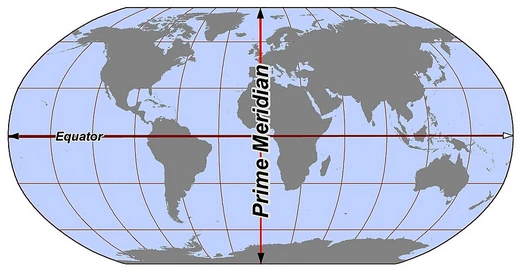
On a spherical reference surface, the graticule is built around Earth’s rotation axis. The poles are where the axis meets the surface. Planes containing the axis cut the surface along meridians (lines of constant longitude), and the angle between any meridian and the Prime Meridian defines longitude. The plane through Earth’s center perpendicular to the axis cuts the surface at the Equator, a great circle. Planes parallel to the Equator create circles of constant latitude—the parallels. The Equator is at 0°, the North Pole at 90° N, and the South Pole at 90° S. For any point, spherical latitude is the angle between the equatorial plane and the radial line (normal to the sphere’s surface). This is called spherical latitude to distinguish it from geodetic latitude and other auxiliary types.
Beyond the Equator, four other parallels are notable. Earth’s orbital plane around the Sun is the ecliptic; the plane perpendicular to Earth’s rotation axis is the equatorial plane. The angle between them is the axial tilt (or obliquity), denoted by i. The tropics lie at latitude i, and the polar circles at 90° − i. The axis tilt changes slowly over time; the values given here are for the current epoch. At the December solstice, the Sun is directly over the Tropic of Capricorn; latitudes below the Antarctic Circle experience daylight, while those above the Arctic Circle are in night. The opposite happens at the June solstice, when the Sun is over the Tropic of Cancer. Only between the two tropics can the Sun ever be directly overhead.
- Definition
- Angle from equatorial plane to normal at a point
- Range
- −90° (South Pole) to 90° (North Pole)
- Symbol
- Greek lower-case letter phi (ϕ or φ)
- Measurement units
- Degrees, minutes, seconds, or decimal degrees
- Reference surfaces
- Sphere or ellipsoid of revolution
- Key parallels
- Equator, Tropics, Arctic and Antarctic Circles
Lore & Background
Latitude is a geographic coordinate specifying the north-south position of a point on Earth or another celestial body, expressed as an angle ranging from -90° at the South Pole to 90° at the North Pole, with 0° at the Equator. Lines of constant latitude, known as parallels, run east-west as circles parallel to the Equator. The definition involves two levels of abstraction: the physical surface is first modeled by the geoid, a surface approximating mean sea level, and then the geoid is approximated by a simpler reference surface, typically a sphere or an ellipsoid of revolution. The geodetic latitude of a point is the angle between the vector perpendicular to the ellipsoidal surface and the equatorial plane. On a spherical model, the graticule is formed by meridians (lines of constant longitude) and parallels (lines of constant latitude), with the Equator as the primary reference. The latitude angle is usually denoted by the Greek letter phi and is measured in degrees, minutes, and seconds, or decimal degrees, north or south of the Equator. For navigational purposes, positions are given in degrees and decimal minutes. The precise latitude of a feature is not unique due to different reference ellipsoids; this is critical in accurate applications like GPS, though in common usage the reference ellipsoid is often unspecified. Latitude determination historically used the meridian altitude method in celestial navigation, while modern precise measurement relies on understanding Earth’s gravitational field for theodolites or GPS satellite orbits, falling under the science of geodesy.
Reader's Guide
Latitude is fundamental to geographic coordinate systems, enabling precise location specification on Earth and other celestial bodies. Its determination has evolved from celestial navigation methods, such as the meridian altitude method, to modern GPS technology requiring an understanding of Earth's gravitational field. The concept is central to geodesy, the science of measuring Earth's figure and gravitational field. In common usage, the reference ellipsoid is often not stated, but for accurate applications like GPS, specifying the ellipsoid (e.g., WGS84) is essential. Latitude's significance extends to defining climatic zones through named parallels like the Tropics and Polar Circles, which depend on Earth's axial tilt.
Did You Know?
- Latitude ranges from −90° at the south pole to 90° at the north pole, with 0° at the Equator.
- The term latitude normally refers to geodetic latitude, the angle between the normal to the ellipsoidal surface and the equatorial plane.
- In English texts, latitude is usually denoted by the Greek lower-case letter phi (ϕ or φ).
- The latitude of the tropical circles equals the axial tilt, and the latitude of the polar circles is its complement.
The Geometry of Parallels
A circle of latitude is, at its core, an imaginary east–west ring that stitches together every point on Earth sharing the same angular distance from the Equator. Because these rings are parallel to one another—meaning the flat planes that contain them never intersect—they are commonly called parallels. What sets them apart from meridians is a crucial geometric fact: every circle of longitude is a great circle passing through Earth's centre, whereas parallels are small circles that shrink as you move poleward. The Equator alone is both a parallel and a great circle, making it the longest of all latitude lines. The length of any other parallel can be derived with a simple cosine function; for instance, the 60th parallel north or south measures exactly half the Equator's circumference because the cosine of 60 degrees equals 0.5. A point's exact position along a given parallel is then specified by its longitude, completing the two-coordinate system that lets us pin down any location on the globe.
The Five Great Dividers
Five principal circles of latitude carve the globe into its major geographical zones. At the centre sits the Equator at 0°, the ring equidistant from both poles and the sole parallel that qualifies as a great circle. Flanking it are the Tropic of Cancer at roughly 23°26′ N and the Tropic of Capricorn at the same distance south, marking the extreme latitudes where the Sun can appear directly overhead at the June and December solstices respectively. Farther out, the Arctic Circle at about 66°34′ N and the Antarctic Circle at the mirror-image southern latitude define the boundaries beyond which the Sun can hover above or dip below the horizon for a full 24-hour stretch during the solstices. The Equator's position is locked at 90 degrees from Earth's rotational axis, but the other four circles shift subtly because their latitudes are derived from the axial tilt. Together these five lines delineate the tropical, temperate, and polar zones that shape climate, daylight, and ecology across the planet.
A Tilt in Motion
The latitudes of the Tropic and Polar circles are not permanent fixtures; they drift because they are defined by Earth's axial tilt relative to its orbital plane. If the planet's axis stood perfectly upright, the Sun would always trace the horizon at the poles and pass directly overhead at the equator, and none of the four non-equatorial circles would exist at all. Over tens of thousands of years these incremental shifts nudge the Tropic and Polar circles northward or southward, subtly redrawing the boundaries of the zones they define.
Lines on Maps and Borders
How a circle of latitude appears on a flat map depends entirely on the projection chosen. On an equirectangular chart centred on the Equator, parallels render as evenly spaced horizontal lines. The Mercator projection keeps them horizontal and parallel but stretches the spacing near the poles to preserve local shapes and scales, while the Gall–Peters projection compresses that spacing so that relative areas remain visually accurate. On most conical or azimuthal projections the parallels are neither straight nor parallel at all. Beyond cartography, latitude arcs serve a practical political purpose: where deserts or featureless terrain offer no natural boundary, governments simply draw a line. The northern and southern borders of Colorado sit at 41° N and 37° N, and roughly half the United States–Canada boundary traces the 49th parallel. Between the Equator and each pole there are 89 whole-degree parallels, but in practice coordinates are recorded to far finer precision using decimal degrees or minutes and seconds.
Frequently Asked Questions
What does latitude actually measure?
Latitude tells you how far north or south a location sits relative to the Equator. It is expressed as the angle between the equatorial plane and the line perpendicular to the surface at that point.
What are the minimum and maximum latitude values?
The scale runs from 0° at the Equator up to +90° at the North Pole and down to −90° at the South Pole. Any value outside that range does not correspond to a real point on Earth's surface.
What symbol do geographers use for latitude?
The standard notation is the Greek lowercase letter phi (ϕ or φ). In coordinate pairs it is typically written alongside lambda (λ) for longitude, as (φ, λ).
What are the most important lines of latitude?
The Equator (0°), the Tropics of Cancer and Capricorn, and the Arctic and Antarctic Circles are the five major named parallels. They mark key boundaries for seasonal sun angles and polar day-and-night phenomena.
How does latitude work together with longitude to locate a place?
Latitude supplies the north-south component while longitude supplies the east-west component, and the two together pin down a unique spot on the globe. On a sphere or reference ellipsoid, that (φ, λ) pair is all you need to specify any location.
More in Lines & Hemispheres 1-24
Spotted an error? Know more?
This is a living reference — every entry is fact-audited, and reader corrections feed straight into our audit queue. Suggest an edit · See this site's audit record